


Setting out from Gate B, follow Fernberg Road westwards to the T-junction with Boundary Road and turn right proceeding to the roundabout and then follow MacGregor Terrace up to the junction with Jubilee Terrace where you cross at the lights to turn right again before turning left down Coopers Camp Road a short distance on. Having endured the noise and fumes of heavy traffic, you will be pleased to learn that most of the remainder of this walk will take you through quiet suburbia, parks, or bushland. Walking on the right or northern side of the road, you will soon come to Lewin Street where you turn right before turning down Empress Terrace at the next corner.
This pocket of Bardon bounded by Jubilee Terrace, Coopers Camp Road, and Ithaca Creek was originally subdivided as the Jubilee Estate at the time of Queen Victoria’s Golden Jubilee and hence its streets bear regal names including Coronation Street, Accession Street, and Crown Street, the latter of which you will soon pass on your right as you reach Jubilee Park situated in the midst of this pleasant and leafy neighbourhood. Continue through the park taking the path along its southern side until you reach Fletcher Parade which you should cross.
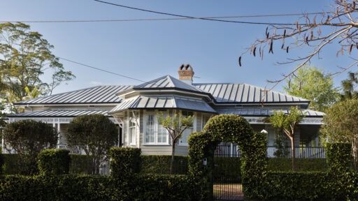
Follow the path to the footbridge you see ahead of you a little to your left and cross Ithaca Creek into Ashgrove. Turning left, follow the path along the creek and use the underpass to avoid having to cross Coopers Camp Road. The path will bring you to Dawn Street which you follow, keeping the creek on your left, and continue along Kamber Street where, after rounding a bend, you will enter Moonya Street on your right. On the left side of the road at Number 15, you will see a handsome colonial house with a front verandah and a large multisided room projecting centrally. This building was originally located on the grounds of Old Government House at Gardens Point1. When the Governor moved to Fernberg in 1909 the house was relocated there to serve as offices and accommodation for the Official Secretary and the Aide-de-Camp. For some time, the central room also served as the Governor’s study. Having been sold for removal in 1938 it found its way to its current location.
Continue up Moonya Street, turn left into Dawn Street, right into Sunrise Street, and then proceed up Milpera Street to its junction with Davies Road. Looking back down Milpera Street, the prospect of verdant, neatly tended gardens surrounding comfortable suburban homes is much altered from the dusty street of recently built Housing Commission weather-board cottages in 1949, most now much altered and enlarged.
Now, walk up Davies Road to its junction with Atthow Avenue and then down to the left until you reach Rangeview Place which happened to sit opposite my parents’ home from the late 1940s to the mid-1960s. At that time, it was the junction with Barnett Road which ran an unsealed course through to the sealed section of Barnett Road and in fact, still does. Walk about halfway to the Blue Care Centre and enter the dirt path on the left turning almost immediately to the right and proceeding until you reach the dirt road which you now follow through the bushland where the children of my generation ranged free beyond the reach of parental supervision. You are surrounded by open eucalypt forest, and you will occasionally see some evidence of the rocky outcrops which come to the surface towards Mt Coot-tha, particularly on the high side of the track. Follow the signs to Barnett Road South and you eventually emerge once more into suburbia. Carefully descend the steep sealed road which will eventually take you along Ithaca Creek to Tate Bridge where you cross and enter Bardon Esplanade on the other side of the creek. Walking along the esplanade you are shaded by large eucalypts and introduced trees while closer to the creek there are rainforest species and a lush understorey.
Before you reach Bowman Park, there is a storyboard on the left providing some details of indigenous activity in the area and of early settlement. Follow the path close to the creek, keeping the oval on your right. The oval was at one time surrounded by a single railing, white wooden fence to aid in determining 4s and 6s when grade cricket was played there. As you walk around, you will note that some of the posts remain. When you are opposite the football clubhouse, take the side path to your left where a storyboard tells of efforts at revegetation, the results of which surround you. Walk on and cross Bowman Parade before proceeding east to turn up Cecil Road and then The Drive. Halfway up The Drive, on the high side, you will see the steep gabled stone edifice of Bardon House, originally built on 39 acres by Joshua Jeays, an early mayor of Brisbane, in the early 1860s2.
The house now sits on the grounds of St Joseph’s Catholic Primary School.
At the top of The Drive, turn left into Simpsons Road and proceed until you reach MacGregor Terrace where the downhill grade makes for easy walking until you return to Fernberg Road and the gate of Government House.
1 Government House Queensland Conservation Management Plan, April 2005.
2 J. Hogan, Historic Homes of Brisbane, National Trust of Queensland, 1979.
Scenic Spots
Former Government House Office Building

Former Government House Office Building
Visit 15 Moonya Street, a relocated colonial house with a storied history, originally part of Old Government House at Gardens Point and later serving as offices and accommodation for the Governor’s staff before being moved to its current location in 1938.

Bowman Park Storyboards

Bowman Park Storyboards
These provide insights into Indigenous activity and early European settlement in the area, and offer an opportunity for reflective pause.
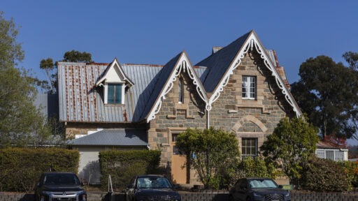
Bardon House

Bardon House
Built in the early 1860s by Brisbane’s first mayor, Joshua Jeays, the steep-gabled stone structure stands as a striking example of Brisbane’s historic homes. It is a rare surviving link to the area’s colonial past.